Cliff jumper, South Point, Na'alehu, Big Island - Monday, March 10, 2025

Cliff jumper, South Point, Na'alehu, Big Island - Monday, March 10, 2025
Showing posts with label 2015 flood. Show all posts

Thursday, August 15, 2019

Distressing Defensive Driving Day - Thursday, August 15, 2019

When I planned this trip in March, I researched Volksmarches, activities, museums, capitals, and other points of interest. We decided that rather than move the RV every 1-2 days, we would set up "base camps" for a week and foray out (up to 1-1/2 hours away) to our bucket list items, take care of that part of our vacation, and move on to the next base camp.

The first reality check came when I tried to make reservations in February for June, July, and August in New York and New England. It was too late to get one week in most campgrounds, the weekends were booked. This led to splitting a one-week reservation in one campground, to making two reservations--3 nights in one campground, and 4 nights in another--in the same area.

Being unfamiliar with routes, grades, low underpasses, traffic, the narrowness of streets through old towns, etc., I did the best I could with our route. We use the Rand McNally Trucker's Atlas, 2019 version, and look at routes on Google Earth Street View if we're really unsure. We even drove one highway in advance to see if we should take it. None of that prepared us for today's journey from Lincoln, New Hampshire, to Rutland, Vermont.

Mt. Liberty, Mt. Flume, and Mt. Osseo (far right)
at Franconia Notch State Park, Lincoln, NH.
All was well at the beginning of the day. We decided not to take the route we had driven two days earlier, which was SR 112 from Lincoln, NH to Bath, NH. The road was narrow, curvy, had a 12% uphill climb and a 9% downhill. 

Instead, we headed up I-93 to Littleton, NH, and took U.S. 302 west toward Bath. I-91 was the route we took south. That in itself was very mountainous. 

I was driving and saw the exit for I-89 north, but didn't realize that was the highway we needed to take to get to U.S. 4 west to Rutland. I was distracted by traffic merging onto the interstate. 

We stopped at the Rest Area just south of I-89. Bob drove after our stop and I looked more closely at the map. I'm glad I did because I realized we were going the wrong way. With all the mountains and small roads, it would be a very long trip to go any other way than I-89 to U.S. 4 west. Bob turned us around at Hartland, VT, and shortly we were back to take I-89 north. Our exit for U.S. 4 west came up quickly and we exited.

This is where things started to get exciting. U.S. 4 is a mostly narrow, two-lane highway (one lane in each direction). It is the truck route through this area. That was both good and bad today. 

The speed limit on the highway varied from 25 (school zone) to 50. Bob was going the speed limit most of the time (except the really steep climb up toward Killington Ski Resort). 

Right from the start, a line of cars started to form behind us. Bob pulled over a couple of times when there was a big turn-out and it was safe to do so. We made it past the congested Quechee Gorge tourist area with no pedestrians darting across the road in front of us. 

Then we got to the mountains and things got interesting. Bob pulled over at a ski lift area to let more cars go by. 

At one point, there was a blind curve ahead of us where the oncoming traffic was on a downhill run. We were coming up on the curve when a semi-truck coming down and around the corner drifted two feet too wide into our lane. There was nowhere for us to go. We had a guard rail on the passenger side about one foot away. Bob and I were freaking out. Thank goodness, the driver of the semi got his truck under control just as he reached us. That was such a close call. 

Here's what else stressed us out:

  1. Construction zone with flagger and only one lane. This was the most minor stressor of the day.
  2. A pick-up truck coming toward us flashed his headlights at us. We were cautious and wondered what lay ahead. As we rounded a blind corner in a small town, there was a car stopped in the oncoming lane and a police cruiser with lights flashing behind them in that lane. We were just figuring out that the car and policeman were blocking the lane when the car behind the policeman decided to go around them and was coming at us head-on in our lane. Thankfully, we were going slower than the speed limit, because of the warning from the pick-up, and were able to slow down more so we wouldn't hit the oncoming red sedan.
  3. A wide load accompanied by a pilot car and two police cars was coming toward us. It was a straight stretch of road and we pulled over on the one foot of shoulder on our side and the wide load was able to do the same on the other side. We stopped and made the cars behind us stop too.
  4. Cars were turning left from the one highway lane headed west because there were very few left-hand-turn lanes. Some did not signal their intent very far in advance.
  5. Woodstock/South Woodstock, Vermont. A very charming New England town with NARROW streets, lots of summer tourist traffic, and traffic jams. Bob narrowly missed hitting one of the lime green "Stop for Pedestrians in Crosswalk" signs in the middle of the street with his rear-view mirror.
  6. By this time, Bob was asking rhetorically, "What else can this drive throw at me?" As soon as he said it, about six people came out from behind a tanker truck to cross at the crosswalk in front of us. One was in a wheelchair. Luckily, we saw them in plenty of time and slowed to a stop.
  7. When we got to Rutland, we found out the Vermont State Fair is going on and the main street was jammed with traffic trying to get to the fair parking. Sheesh.
We finally made it to our destination, set up camp, and then fell asleep in our recliners. It was supposed to be about a 2 hour and 45-minute trip. It took us 4-1/2 hours. 

In the next four days, we have to make the reverse trip on U.S. 4 to I-89 two more times with the pick-up truck, and then we have to traverse it again with the 5th wheel to head to Maine on Monday. Wish us luck.

I was too preoccupied to take photos today.

On the plus side, Iroquois Family Land Camping in Rutland is a very peaceful, bucolic campground. It will be our respite from U.S. 4! Have a great weekend everyone.


Sunday, July 19, 2015

Enough Activity to Fill Two Days (Part 2) - Sunday, July 12, 2015

The second half of Sunday, we drove to Wimberley, Texas on the Blanco River and Cypress Creek. You may remember all the flooding in our part of Texas on Memorial Day weekend 2015. Wimberley got the worst of it. A 40' tall wave of water slammed into a bridge, destroying it. Over 300 homes were either pushed off their foundations, floated downstream or had flood water flowing through their homes. Twelve lives were lost.

What led to this horrible destruction? Upstream from Wimberley, six inches of rain fell in three hours. That was in addition to rain that had already fallen, leaving the ground saturated. All that water had to go somewhere. It went downstream, picking up speed and debris as it swept downhill. Mashable.com has the best description of the chronology of events.

We love Wimberley and have done Volksmarches there, hiked with friends to the top of Prayer Mountain, explored Jacobs Well and The Blue Hole, and shopped and dined in this "little bit of heaven," as described by Wimberley residents. The "downtown" is just plain cute with good eateries.

But I'm getting ahead of our day's chronology. For our drive north to Wimberley, Bob wanted to show me the beautiful area he runs in when he's in the final days of training for the San Antonio Rock 'n' Roll Marathon in November.

The road took us along the Guadalupe River (which had no damage), through gorgeous Texas Hill Country, past many businesses where you can rent "toobs" to go down the river, and lots of RV parks. The route is lovely.

Tree tunnel along the Guadalupe River
Guadalupe River below Canyon Lake
You can get it all here!
RV park on the riverbank
American flag flying over the road

Lone kayaker on the Guadalupe River
A vintage Airstream food truck in Sattler, Texas
We drove through the town of Canyon Lake and meandered over hill and dale to get to Wimberley via a back way. The first sign of damage from the flood was the guardrail on the bridge over the Blanco River. You can see how the trees and debris bent the metal. Look how low the river is now. The main part of Wimberley's shopping/dining area was not damaged by the flooding.

Damaged guardrail on Blanco River Bridge
Wimberley storefront
By the time we made it to Wimberly, our tummies were growling, so we parked and headed to Cypress Creek Cafe for lunch. The cafe is decorated inside with guitars that have been turned into works of art and are available for purchase.

Cypress Creek Cafe
Two artsy guitars above our table
For lunch, I had the best Cobb salad ever (in my opinion). It was loaded with chicken, black beans, avocado, tomato, hard boiled egg slices and I ordered it with honey mustard dressing on the side. It was definitely yum-tastic! Bob had a mahi mahi sandwich which he gave two thumbs up. He helped me eat my salad. We resisted the urge to have a slice of their Italian Cream Cake (so excellent!).

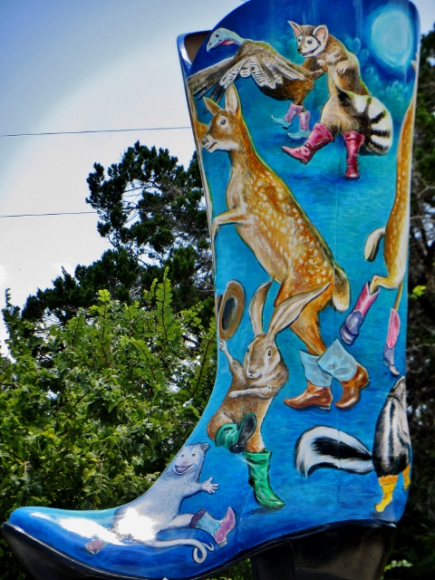
After lunch we walked down to Cypress Creek (no major damage) and hoofed it around town looking at all the six-foot tall painted boots (Bootiful Wimberley). We loved them!

"Homegrown Music," by David Richardson
Cypress Creek
Turtles on the rocks - Cypress Creek
"Boot Hill," by Dan Moore
Boot painting by Bejat McCracken
"East Meets West," by Rozi Turnbull
Once back in the car, we headed out to River Road along the Blanco River. What we saw saddened us deeply. People's homes were gone or ruined. Bald cypress trees that started growing in the 1400s, were snapped, uprooted, laid waste...or not touched at all.


This beautiful home is ruined. You can see
the right side wall is no longer attached at the bottom.
Close up of the roof collapse
Side view of roof collapse
A whole row of old bald cypress trees downed
Once stately trees used to provide much-needed shade
Part of a house in the debris along the riverbank
Some trees seemed untouched, while others next to
them were down.
Stairs to the river were washed away - now
perilous ladders line the bank.
More devastation
A number of houses were gutted
The foundation is here...the house is gone.
We then drove back to the untouched part of Wimberley, past the Hotel Flora and Fauna. That's a place I'd love to stay.

Hotel Flora and Fauna was not touched
Could not find name or artist for this boot
The Blanco River in Wimberley
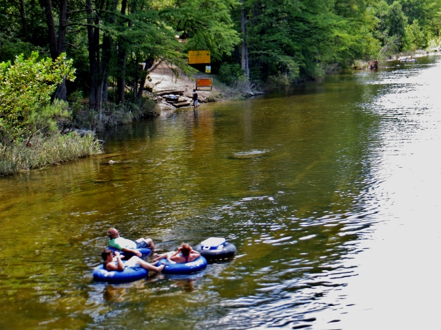
Driving home, we returned along the Guadalupe River. In Texas, toobing is THE thing to do on a hot summer day. You'll notice the cooler has its own tube!!

Must have the cooler along!
Toobing the Guadalupe River near Sattler, Texas
That's it for today. Thanks for reading.