Sunset, Kailua-Kona, The Big Island, Hawaii, March 11, 2024

Sunset, Kailua-Kona, The Big Island, Hawaii, March 11, 2024

Saturday, April 15, 2023

Silver City and Fort Bayard Historic Site (Including the Bataan Memorial), New Mexico, Part 2 - Saturday, April 15, 2023

Continued from Part 1...

After lunch at Dairy Queen, Susan and I returned to our hotel rooms for a siesta before we went to Fort Bayard Historic Site and the Bataan Memorial exhibit. We had tried to find the correct parking lot for the Bataan Death March Memorial a couple of days ago when we did the Dragonfly Trail; however, when we got to the parking lot it was late in the day and we weren't positive it was the right place. Today, we found that we had been in the correct parking lot.

After a very short walk from the parking lot, we came to the Bataan Death March Memorial. This Bataan incident began in December 1941, in Bataan, Philippines. 

"Remembering Bataan: Honoring our Heroes," fall 2008-
spring 2010. Art was done by the Youth Mural Program.

A commemorative sign on the gate states:

"Within hours of their December 7, 1941, attack on Pearl Harbor, the Japanese military began its assault on the American outposts in the Philippines. Manila was a perfect Japanese resupply point for their planned conquest of the southern Pacific. On December 22, 1941, 43,000 men of the Imperial Japanese 14th Army went ashore on the main island of Luzon.

"General Douglas MacArthur, commander of the U.S. Army Forces in the Far East, ordered American troops to retreat to the southern Bataan peninsula. Troops in Bataan resisted the Japanese until April 9, 1942, when 22,000 American and 54,000 Filipino soldiers surrendered. The Japanese military followed the Bushido code, in which surrender was shameful and death was preferrable. Prisoners started out from Mariveles on April 10, and were force-marched north 65 miles with no food or water to the San Fernando railhead. At the San Fernando railhead, as many as 100 prisoners were stuffed into sweltering (16' long x 8' wide x 6' high) box cars for the 25-mile trip to Capas, then they walked nine miles to Camp O'Donnell."

 Other signs at the memorial added to the story:

"When the over 70,000 soldiers were surrendered, there were over twice as many prisoners as were expected by the Japanese. The prisoners of war were in terrible shape - sick, wounded and malnourished. The Japanese had to get them out of the way as soon as possible. That meant moving them 60 miles  in sweltering heat and 100% humidity on what became the infamous 'Death March.'"

"POW Camps: The prisoners of war (POWs), weak, starving, thirsty and sick arrived at their first and for many their last POW camp, Camp O'Donnell, nicknamed 'Camp O'Death.' Around 50 American prisoners would die every day. There they received very little food and water but much brutality and torture along with many diseases like beriberi and pellagra to go along with the malaria and dysentery which they already had."

"Hell Ships: The Empire of Japan required great numbers of workers and huge quantities of raw materials in order to wage war against the Allies. In May 1942, the Japanese began transferring its captured POWs by sea in cargo-laden ships. The holds were floating dungeons, where inmates were denied air, space, light, bathroom facilities, and adequate food and water - especially water.

"Thirst and heat claimed many lives, as did summary executions and beatings, yet the vast majority of deaths came as a result of so-called 'friendly fire' from U.S. Allied naval ships, submarines, and aircraft."

 "After: After returning home with battle fatigue a.k.a. shell shock, now PTSD, they had difficulties reintegrating into family life, with their depression, claustrophobia, nightmares, flashbacks, alcoholism, and breakdowns. Some had marital difficulties, some committed suicide, and others simply carried on while not sharing their stories. BUT, they were paid $1.00 a day for each day they were a prisoner."


This Bataan Memorial honors New Mexico's fallen soldiers.

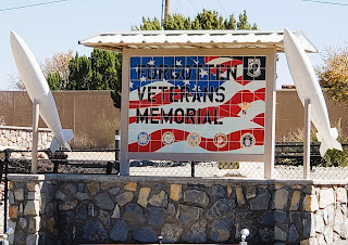
When we finished reading all the history here, we walked over to the Forgotten Veterans Memorial. We walked the path through the compound.


The Forgotten Veterans Memorial overlooks
Fort Bayard.

In the pavilion here, there is a sculpture of a table for the forgotten veteran in a restaurant.  It was very moving. With the afternoon lighting in the pavilion, it was hard to get a picture that would do it justice.

From the Forgotten Veterans Memorial, we walked back through the parking lot, across the road, and entered Fort Bayard. This 468-acre fort is not only historically rich; it is also abundant in natural beauty. Visitors can choose from a variety of programs and special events which include re-enactments, presentations, and annual celebrations. Guided tours are given throughout the year and pass through the stately officers' quarters or "Doctors' Row," which faces the parade ground.


Our impression is that Fort Bayard has been left to decay. It's like a ghost town. There have been talks over the years to restore parts of the Fort, but nothing has ever come of them. The way it looks now, it would take a whole lot of money to bring these buildings up to current standards!

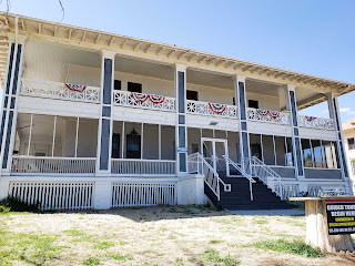
This is the first Officer's Quarter building we saw.
It's in very bad shape.

Guided tours start here. I heard there is a 
small museum inside with limited hours.

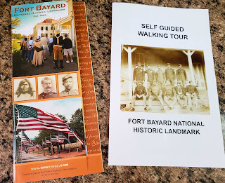
The information found in this part of my blog is retrieved from two different Fort Bayard brochures, multiple historical markers throughout the fort, and my own observations as we walked through this (mostly forgotten) piece of history.


Fort Bayard was established on August 21, 1866. Why a fort here? Let's travel back in time. Copper was mined nearby since at least 1803, when Thomas Jefferson was the president, and this locale was part of the Spanish Empire. Mines here, and many that followed, made this region important to the economies of Spain, Mexico, and eventually the United States. 

In the Southwest, the Apaches had been in bitter conflict with the Spanish and then the Mexican settlers for roughly 200 years. The slaughter of women and children had been fierce on both sides. In order to provide protection for the people extracting the minerals from attack by the native Apaches, who resented and resisted the intrusion into lands they had inhabited for centuries, this fort was needed. 

Lieutenant James M. Kerr, Company B, 125th United States Colored Infantry, ordered his troops to begin building a new post in Apache country near Pinos Altos, New Mexico Territory. The fort was named after 1852 West Point graduate General George D. Bayard, who was killed in the Civil War Battle of Fredericksburg, Virginia.

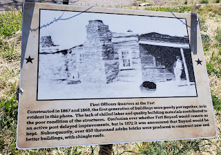
What the original Officer's Quarters looked like.

One tale from the fort in the mid-1860s was of a 22-year-old Buffalo Soldier, a former slave named William Cathey. He joined the Union Army at Jefferson Barracks, Missouri, and was enlisted in the 38th Infantry. He was stationed at Fort Cummings and Fort Bayard. In 1868, he was discharged after a contract surgeon, who treated Cathey, discovered he was a she! Before the infantry, Cathay Williams had been conscripted during the Civil War, where she served as a cook, laundress, and nurse with the Illinois regiment.

Following the Civil War, the Army intensified campaigns against the Apache, with extermination or forced confinement on reservations as the only options. This, along with the use of railroads, artillery, heliographs*, and telegraph, resulted in Geronimo's surrender in 1886.

(*Heliograph: a mirror mounted on a tripod or post on top of a mountain, which used the sun's rays to send messages in Morse Code across long distances. During the Geronimo Campaign of 1886, 24 heliograph stations were used, spanning from southern Arizona to southwestern New Mexico. Morse Code was flashed by mirrors from mountaintop to mountaintop across great distances. In one instance, a message traveled 700 miles in four hours!! The heliograph system served to send messages from areas without telegraphs and where telegraph lines had been severed by the Apaches. This was an extremely effective means of communication during the Geronimo Campaign.)

Second Lieutenant John J. Pershing.

In 1886, Second Lieutenant John J. Pershing of World War I fame, had his first posting at Fort Bayard with the 6th Cavalry, just two weeks after Geronimo's surrender. He was assigned the task of establishing heliograph stations from Fort Bayard to Signal Peak, and then on to Fort Stanton.

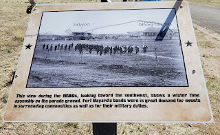
The following historical signs show what life was like in the mid-to-late 1800s.


The parade ground was used for many activities.

The fate of the Apache scouts.

An interesting lesson was learned.

From 1866 until August 28, 1899, Fort Bayard had been a military post. That came to an end in 1899 when the Army Medical Corps took over the property. the War Department authorized Surgeon General of the Army, General George M. Sternberg, to establish a hospital at Fort Bayard for use as a military sanitorium, the first of its kind. His strong interest in the treatment of tuberculosis was instrumental in retaining the fort. 

An interesting theory about treating tuberculosis.

When the Army Medical Corps took over the property, it was soon realized that the fort would need to be redesigned for its new mission. Over the next 20 years, changes included:
  • Doctors Row houses were constructed from 1906-1911 as homes for the Army doctors assigned to the Fort Bayard Tuberculosis Hospital.
  • Nurses Quarters opened in 1910.
  • A new water tank was erected.
  • A glass solarium was constructed within the first few years of the tuberculosis era.
  • Barracks were replaced with "ambulatory wards" for those patients who were not confined to constant bed rest.
  • Trees and landscaping were added to the parade ground. Picnics, band concerts, boxing matches, and leisurely strolls were all part of daily life revolving around the parade ground. In later years, a baseball field was added.
  • A Hospital Administration Building was added in the final years of the facility's time as an Army Hospital.
  • A wide assortment of patient wards and other facilities were added.
New staff included:
  • 1889 - Army surgeon Major Daniel M. Appel. He found that open air at high elevations was beneficial to his patients, believing that the resulting increase in red blood cells contributed to health.
  • 1904-1917 - Commanding Officer Army surgeon Dr. George E. Bushnell believed convalescing soldiers recovered more quickly at high elevations, with clean air, abundant sunshine, and low humidity. In addition, wholesome foods from the post's gardens, dairy herds, and poultry and livestock, contributed to the patients' welfare. Major Bushnell joined Appel in pioneering research and treatment of tuberculosis. 
  • 1900 - Dita Kinney, contract nurse, arrived at Ft. Bayard U.S. Army Hospital to serve as Chief Nurse. In 1901, she became the first director of the Army Nurse Corps.
World War I saw Fort Bayard's patient population grow. Separate buildings were constructed for World War I lung casualties. Many victims of poisonous gases were treated here. Here, it should also be noted, 1918 influenza patients were isolated from the national epidemic. 

From 1900 to 1922, the U.S. Surgeon General continued to maintain the majority of the buildings at the fort for the treatment of tuberculosis. 

In 1920, the Army turned Fort Bayard over to the U.S. Public Health Service, ending a 54-year era of Army administration. During that period, the U.S. had passed from a suffering nation trying to recover from the devastation of the Civil War to a world power. Ten different presidents had held office, and the number of U.S. states had increased from 36-48, with New Mexico added as the 47th in 1912; and the native Apache people no longer roamed free, as many had been dispersed to reservations in other states.

A new, modern Veteran's Hospital was dedicated in 1922 to better care for its more than 1,000 patients and to add 250 beds.

In 1944, 100 German prisoners arrived at Fort Bayard from Lordsburg's POW camp to fill a labor need. As prisoners, they cared for the burial grounds, which became a National Cemetery in 1976. They also helped repair buildings, maintain grounds, and tend the orchard. Prisoners were well cared for and participated in plays and Christmas celebrations with families at the post.

In 1965, the U.S. Department of Veterans Affairs transferred a well-maintained Fort Bayard to the State of New Mexico. From 1965 to 2010, Fort Bayard served as a long-term care facility for veterans, civilians, and needy patients. The quality of care was good in spite of the surrounding buildings and grounds that suffered from neglect.

A new Fort Bayard Medical Center was completed in late 2010. Staff and patients were transferred to the state-of-the-art facility in November.

At the end of our exploration of these three points of interest, we had walked 5 km. (That makes up for the 5 km we stamped in our Volksmarch books for the Catwalk Canyon Recreation Area walk that we weren't able to do. Because of snowmelt farther north, the entrance road to Catwalk Canyon was flooded and closed to vehicles. We will have to enjoy the Catwalk Canyon walk another time.)

As you have read, we had quite a busy day! Both of us were exhausted. 

Thank you, thank you, thank you to the Sun Country Striders Volksmarch Club for organizing all these great walks for us. And a HUGE amount of appreciation to the volunteers who made sure we found everything we needed. (Here's looking at you Henri and Eileen!)

Tomorrow, we check out of our hotel and start driving home. In the morning, we will do the 5 km Deming Volksmarch and then the 5 km Rockhound State Park Volksmarch.

Silver City and Fort Bayard Historic Site (Including the Bataan Memorial), New Mexico, Part 1 - Saturday, April 15, 2023

Be forewarned...you are going to be reading a lot of history in today's two blogs!

Having been in the area since Thursday, Susan Medlin and I were raring to explore Silver City and Fort Bayard. When we parted yesterday, we planned to visit Fort Bayard first thing in the morning and then do the Silver City walk. Susan came to my car and said we would do the Silver City 10 km Volksmarch first. Whatever.

The walk started at the Murray Ryan Visitor Center. The exterior of the building is a work of art showcasing the Continental Divide Trail, Gila River, native plants, and the Apache and Mimbres cultures. The artwork was done by the town's Youth Mural Program. The visitor center gave me two brochures detailing the art program.

Silver City, New Mexico's Youth Mural 

The top and bottom tiles were made by students
and depict the history of the Apache.

This mural represents the Gateway to the 
Continental Divide Trail (CDT).


Other art and history graces the exterior of the visitor center. 

This area was once a lush, grassy cienega (or wetland) and attracted humans for at least a thousand years. Early Spanish explorer Juan Antonio Garia reported in 1779 that La Cienega de San Vicente was "a summer settlement for wood cutters, sheepherders, and Indian traders." More on this later.

Mining activity in the region began in 1804 with the Spanish development of the Santa Rita del Cobre Mine twelve miles to the east. Copper was delivered to Mexico City by mule train. (That's a long haul!)

The historical marker about the Army of the West tells what happened during the War with Mexico in 1846. General Stephen Watts Kearny, commander of the Army of the West, led his troops, scout Kit Carson, and a staff of topographical engineers through what would become Grant County. On October 18, they held council with Chiricahua Apache leader Mangas Coloradas near Santa Rita del Cobre Presidio. Previously employed at Santa Rita and familiar with the area, Carson led them to San Vicente de la Cienega, today called Silver City, before heading westward along the Gila River to California.

On November 16, 1846, Lt. Colonel Philip St. George Cooke, Antoine Leroux, Jean Baptiste Charbonneau, other scouts, and the Mormon Battalion of Volunteers including four wives, traveled a more southern route. They camped near Cooke's Peak, later called Cooke's Spring. Their orders were to blaze a wagon road to the Pacific. The 1858-1861 Butterfield Overland Mail followed portions of Cooke's Road.

Later in the 1860s, explorers and territorial boundary surveyors noticed signs of other mineral deposits, triggering a gold rush in nearby Pinos Altos. In 1870, miners from across the continent poured in by the hundreds with news of a silver discovery in the hills near La Cienega de San Vicente. Silver City became an instant boomtown!

Summer monsoons bless the arid Southwest with rain--sometimes violently so. This valley drains the Pinos Altos Mountains and the Continental Divide. Unfortunately, town founders - unfamiliar with local conditions - placed Main Street right in the path of the watershed's natural drainage route. The results were disastrous.

Each year, rainstorms caused damage to the main thoroughfare; each year, residents made repairs to the unpaved street. With each passing storm, Main Street wore deeper. It became an arroyo, a gully, and eventually a gorge. 

No one realized that the problem lay not in the rainfall, but in the uncontrolled wood cutting and grazing of the surrounding watershed. Wood was harvested to heat homes and power steam engines for the mines. Soil collection for adobe bricks made matters even worse.

After the major flood of 1895, the town gave up on Main Street and built a pedestrian footbridge over what is now San Vicente Creek. In 1902, another devastating flood carved the deep gulch that locals now call the "Big Ditch."

The parking lot at the visitor center is where our walk directions started. We passed by another art installation. This consisted of chicken wire holders along the visitor center wall. The chicken wire holds hundreds of small clay figures. An exhibit inside the visitor center explained this art project.


Close-up of the clay figures.

Explanation of "The People and Clay."

Next, we passed by and looked inside the Billy the Kid Cabin. The cabin is typical of the late 1800s, where Billy the Kid and his mother lived. The cabin was used in the movie "Missing" and donated to Silver City by director Ron Howard.

Billy the Kid Cabin.


Inside Billy the Kid Cabin.

You have learned about how the Big Ditch formed. Now, you will get to see it up close and personal. The following five photos let you experience the first part of our walk.


Susan Medlin hiking the Big Ditch Trail.

Wildflowers.

It was nice and cool in the "Big Ditch."

Susan Medlin crossing a pedestrian bridge 
over the Big Ditch in Silver City, NM.

From the Big Ditch, we went up a long set of stairs to find the sign for Lions Park. Didn't see it, wandered around a bit, and eventually found it. I went off on my own up a steep hill to a bridge; Susan Medlin, Regina, and Sarah Gregory Long all went into town a different way. 


We went up and down these stairs while
looking for the Lions Park sign. Didn't see it.

We saw this gorgeous mural.

Just after the above mural is when we split and went different ways. I ended up at the mural below on a bridge. There was a steep dirt trail up to the bridge. No one else wanted to attempt it, so they all turned around. I went up to the street and found out I had gone one block too far on the directions, so I walked back down the street to find the rest of the group. 

The mural on the bridge.

"Southwest Welcome," 2006,
Youth Mural Art Project.

In a few blocks, I met up with the group again. Sarah and I walked together and photographed murals and talked about fun stuff. Regina and Susan Medlin took off quickly and left us in the dust. Meanwhile, murals abounded.


"Tour of the Gila" mural (2016) honors cycling and cyclists
in Silver City.

Fort Bayard History Mural.

In the photo below is an artwork called "Five Windows." From left to right, the window titles are Mimbreño Heritage (2007), Apache Heritage (2005), Hispanic Heritage (2009), Anglo Heritage (2006), and Multi-cultural Heritage (2008). Each clay and mosaic window frame is a still life laid out on a checkerboard in a landscape. Each window has a lot of essential images from each culture.


This is where I really wanted to go, 
but it wasn't open yet.

Regina was waiting for Sarah and me at this point. So the three of us walked together. Susan Medlin had struck off on her own. The walk was hilly and we saw lots of surprises. The inner courtyard of Tranquil Buzz Coffee House had a little waterfall. 
Courtyard of Tranquil Buzz Coffee House - 
a delightful spot.

Here are other sights along the city streets.

Turtle totem.

A beautifully painted windmill.

The Thomas Conway House, the residence of a prominent
Territorial attorney, built in the mid-1800s by John Flood.

I nicknamed this the Rubik's Cube building.

St. Vincent de Paul Church, 1874.

We continued walking up and down hills through neighborhoods until we came to Western New Mexico University. Regina and Sarah wished to use the facilities at the Museum on campus. I went across the street to take photos of the art at the library. Then I sat in the shade, checked my email, and waited for them to come out of the museum. 

Chihuahuan spotted whiptail.

History of "The Great Race" put on by Western
New Mexico University.

The following five photos are of an art installation called "A Community Reads" and are located at the entrance to the WNMU Miller Library. Participating community members and students each made a clay book spine of their favorite book. These were glazed, fired, and "stacked" into the mural. The overall design was the conception of Aldo Leopold's YCC mural crew led by Diana Ingalls Leyba. The books chosen say much about Silver City's diverse community.

"A Community Reads."

"A Community Reads."

"A Community Reads."

"A Community Reads."

"A Community Reads."

Fleming Hall - University Museum (WNMU).

After 15 minutes of waiting, I guessed Regina and Sarah had stopped to peruse the exhibits in the museum. I continued on alone.

Fine Arts Center Theatre (WNMU).

WNMU entrance sculpture and fountain.

Thomas B. McDonald Student Memorial Center (WNMU).

"Camp: Endangered Species," 2019, 
WMNU Barnard Hall.

"Camp: Endangered Species," 2019, 
WMNU Barnard Hall.

I walked past beautiful homes, the Grant County Courthouse, and Silver City Museum. I decided to return to the visitor center to use the facilities. It was only a few blocks down the road from the courthouse. 

Grant County Courthouse.

Grant County Courthouse.

Silver City Museum.

Silver City Museum.

The following gorgeous mural is at the intersection of Texas and Broadway Streets. The mural theme was proposed by Southwest New Mexico Audubon and designed by Aldo Leopold High School art students under the direction of teacher Alison Phillips. The border consists of blue to red stripes indicative of global temperature changes over the last 100 years. The mural illustrates the bees, birds, butterflies, and bats that pollinate the plants on which animal and human lives rely. The black-and-white Mimbreño designs represent the native culture that thrived before climate change some 900 years ago causing drought and crop failure that forced Mimbreños to migrate elsewhere as early as the 12th century.

"Plants, Pollinators, and Climate Change,"
2019, Youth Mural Program.

A gorgeous new mural is being painted in
downtown on the side of the Toad Creek Brewery.

When I returned to the visitor center, I decided this would be the finish point for my walk. I had 7 km which was fine with me. Susan Medlin was on the 10 km portion of the walk high on a hill. She said she'd be another half-hour before she would return to the car. I took photos inside the visitor center and then read my emails.

Back at the Ryan Murray Visitor Center.

Here are photos from inside the visitor center.

We definitely need to spend more time here!

This mural by Carlos Callejo is above the 
visitor center welcome desk. 

A cute display of local birds.

When Susan got back to the car, we drove down the street to Dairy Queen for lunch. She was so happy to be back in the air conditioning because that last 3 km did her in. The temperature was in the 80s and she hiked up a hill near the end.

This was a very enjoyable walk. It made me want to come back to Silver City with Bob, go to the museums, and take him on a walk around town.

To be continued in Part 2...