Cliff jumper, South Point, Na'alehu, Big Island - Monday, March 10, 2025

Cliff jumper, South Point, Na'alehu, Big Island - Monday, March 10, 2025
Showing posts with label Amarillo Texas. Show all posts

Saturday, July 22, 2017

"It's Easy," She Said - Sun., June 18, 2017

This morning, we have a relatively short drive to Capulin Volcano National Monument where we plan to do a short Volksmarch. Our walk instructions online tell us that the National Monument opens at 8:30 a.m. on Sunday. 

Truth be told, I'm not enthusiastic about this walk. My feet are killing me and I'm tired. Susan has done this walk before and says she remembers that this is an easy, paved, flat walk around the rim of the crater.

We arrive at the Capulin Visitor Center at 8:29 a.m. No one is around. The Visitor Center is closed for remodeling and there is a temporary hut set up where we can pay and check into the park. The sign on the door of the hut says they open at 9:00 a.m. on Sunday. Alrighty then, we'll just settle in an read for a half hour. 

Cars, vans, and trucks arrive in droves between 8:30-9:00 a.m. Boy Scouts and their leaders pile out of the vans. Everyone is standing around waiting for the temporary Visitor Center to open. 

Since we were the first vehicle there, I walked to the door of the hut. I talked to some of the ladies. The Boy Scouts are starting a week-long camping trip and their first stop is Capulin Volcano.

I picked up a park brochure and would like to share a little bit about the volcano itself:
"The Capulin volcano erupted into existence 60,000 years ago. Firework-like rooster tails of glowing, super-heated lava spewed high in the sky, solidified, and dropped back to Earth. The falling debris accumulated around the vent, forming a cinder cone volcano.
"Capulin's birth occurred toward the end of a period of regional volcanism that began 9 million years ago. You can see hills, peaks, and other formations from this period throughout the 8,000-square-mile Raton-Clayton Volcanic Field...
"The cone is chiefly loose cinders, ash, and other rock debris formed by gaseous lava that cooled quickly. The volcano's symmetry was preserved because later lava flows did not come from the main crater but from its boca (Spanish for mouth), at the cone's western base."
"It's flat," she said. Now tell me,
does the top of that cinder cone look flat to you?

After we checked in at the Visitor Center and picked up our walk instructions, we hopped in the van and headed up the road to the top of the cinder cone. "The wheels on the bus go 'round and 'round." And the van went 'round and 'round, and up and up 1,300 feet from the floor of the surrounding plains. Going up, we were on the side looking straight down...no guardrails in sight. Luckily, no one was coming down yet.

When we reached the small parking lot at the trailhead, we saw an elevation sign: 
Yes, you read that right: 7,877 ft.
Let's do the math. Capulin cinder cone's highest point is 8,182 feet above sea level. That means our elevation gain on this trail is going to be 305 feet! NOT a flat easy walk, especially at that elevation. Okay, we've had plenty of exercise leading up to this. I can do it!

We fuel up with a few handfuls of trail mix, put on hats, sunscreen, and take our hiking poles with us. We walk around the corner to head up the trail and there's a chain with a sign that says, "Trail Closed." What? No way.

Just let me say that when you're with a group that includes Boy Scouts, Scout leaders, retired military, worrywarts, etc., you do not just cross the chain. Oh, no. Mustn't break the rules. 

In case you're wondering who the worrywart is, that would be me. My brain goes crazy wondering why the trail would be closed. Perhaps the trail collapsed and the hiking is dangerous, maybe there's a nest of rattlesnakes, and maybe, just maybe, they forgot to tell us in the Visitor Center.

Then a thought crossed my mind, "We have a brochure, maybe there's a phone number that we can call to find out." Sure enough, there was a phone number to the temporary hut. Darren placed the call while a bunch of us stood around wondering why they didn't tell us the trail was closed before we all drove up there. 

When he hung up, he said, "They forgot to remove the chain. The trail is open." Thankfully, there was no lock on the chain and we were able to hike the Crater Rim Trail.

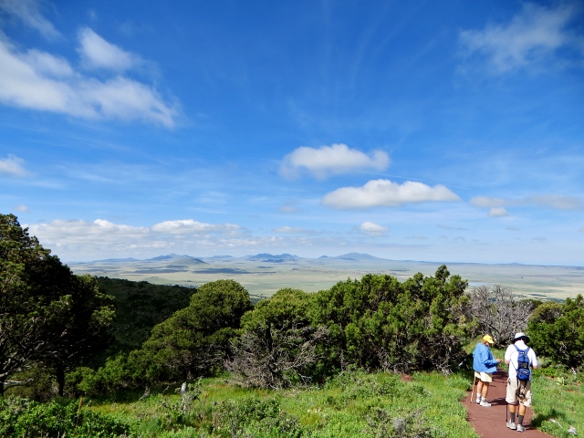
The trail was steep up from the parking lot. I was huffing and puffing within 200 feet. The views were spectacular so after a brief rest, I pushed on to try to catch up with Darren and Susan.


Looking out over ancient lava flows
Lava-capped mesas to the northwest
Moon-Rose
Rabbit Ear Mountain
Susan was always ahead of us. I told her she reminded me of the trainer in "The Eiger Sanction" with Clint Eastwood and George Kennedy. Every time I would catch up to her, she would take off again. I told her I wasn't playing that game and I took my time catching my breath before I set out again.


Susan waiting...for a moment
Here you can see the Crater Rim Trail is not flat

Susan and Darren charging on ahead.
Unknown (to me) wildflower
On a clear day, like today, you can see into four states: New Mexico, Texas, Colorado, and Oklahoma.

Big views
Here is the park brochure's description of the Crater Rim Trail: "Moderate: one-mile loop, paved. Enjoy spectacular 360-degree views. The trail skirts the rim in a series of moderate to steep ascents to the peak's highest point--8,182 feet--and ends with a sharp descent to the parking lot."

Sierra Grande, an extinct volcano rising
2,200 feet above the plain (10 miles from Capulin)
Below is a perfect picture to show you how far we've come up from the trailhead. Look closely at the top one-third of the photo below, you can see how small the cars look from where we are. You can also see the trail down into the crater, and a good view of the crater from here as well.

Looking down into the crater and at parking
We are not yet at the top. If you enlarge the photo below, you might be able to see Susan and Darren down the hill ahead of me on the right past some trees partially blocking the view of the whole trail. From where they are, it's a steep ascent to the very top of the crater rim trail.

Susan and Darren are up ahead on the trail
Fantastic vistas!
Proof I made it to the top
We had perfect weather for long-range views.
Different colors of lichen
Lichen are fascinating!
We are heading down off the Crater Rim Trail. I can tell you the views are well worth the hike!!

Next, we'll hike 105 feet down into the crater on the Crater Vent Trail.


Down into the crater we go
Down by the blocked vent
Time to climb out of the volcano and continue on our way to Amarillo, Texas. We made one stop at a Dairy Queen for lunch. 

In Amarillo, we checked into our motel rooms and waited until early evening to do the 5k Amarillo Volksmarch. Darren swam some laps in the pool in the hottest part of the afternoon. 

We had agreed to meet up for the walk at 7:00 p.m. I went to their room at 7:00 p.m., but they weren't ready to go. During our drive today we had a time change and they thought it was only 6:00 p.m. They would come to my door when they were ready.

The walk started in the heart of downtown Amarillo and we had to drive a few miles to get there. We parked in a lot near a bar and a restaurant. It was Sunday so downtown was like a ghost town.

The first part of the walk was okay. A number of old, interesting buildings were on our route. An interesting fact I learned from one of the history markers is that from 1892 to 1897 Amarillo was the largest rural shipping point for cattle in the nation.
"The Heart of Amarillo" - see photo explanation below

Potter County Courthouse (in the two photos below), is the fifth and final iteration of courthouses in Amarillo, Texas. In the 1920s there was an oil boom in the Texas panhandle. At that time, Amarillo's population tripled, business increased, and eight skyscrapers were added to downtown. This "new" courthouse was built in 1930-1932. More than 500 laborers, local residents of Potter County, applied for work on this job.

Old Art Deco buildings are pretty cool. I love the detail work in the concrete. On Potter County Courthouse below, I was particularly taken by the longhorn hiding behind the entry light. I took a close-up of it below so you can get a better look.

Potter County Courthouse
Longhorn detail - Potter County Courthouse
Globe-News Center in Amarillo, Texas
If you recall, on our Volksmarch in Cheyenne, Wyoming, we saw one of the eight remaining examples of the world's largest steam locomotives, No. 4004, the "Mighty Big Boy." Here in Amarillo is another one of the eight remaining large steam locomotives, No. 5000, "Madam Queen" of the Atcheson, Topeka and Santa Fe Railway.

"Madam Queen" - No. 5000
One of the world's largest steam locomotives
Formerly Santa Fe's Railroad Station
In one of the parks is a sculpture of Rick Husband, native son of Amarillo, Colonel in the USAF, NASA Astronaut and Mission Commander of the Space Shuttle Columbia. Columbia disintegrated upon final re-entry on February 1, 2003. All seven astronauts lost their lives.

Rick Husband
To infinity and beyond. R.I.P. Rick Husband
Amarillo National Bank
When we got about halfway into the 5k Volksmarch, the walk took a turn for the worse. We have no idea why anyone would walk us through an area that was so economically depressed. Most of the stores were out of business, there was graffiti and garbage everywhere. The only reason we can think we were on this street was because it was Route 66. We hurried through as much of this area as we could. The sidewalks were cracked, broken or non-existent. We had to carefully watch our footing. 

In addition to that, a street sweeper machine came along late that Sunday afternoon blowing a wall of dust toward us. We hurriedly walked in an alley over to a different street so we wouldn't be covered in all that dirt. I started sneezing violently and we were at least 1/2 block away from it.


Cute use of painted bicycle rims
Historic Santa Fe Railway Building
Throughout Amarillo, Texas, there are painted horses. That is very fitting because the American Quarter Horse Hall of Fame and Museum is in Amarillo.


Pointed arch - Fisk Medical Arts Building
Gothic Revival architecture
(now a Courtyard by Marriott)
Formerly Fisk Medical Arts Building
While we saw some interesting architecture and learned a little history on this 5k walk, it was not our favorite. Tonight is our last night on the road. Tomorrow, we hightail it home. 

It will be nice to be home with Bob. I missed him on this trip and wished he could have shared it with us.

Thank you for following along. My next Volksmarch driving trip with Susan and Darren will be in August to Grand Island, Nebraska, for a five-walk weekend centering around eclipse events. Stay tuned, there's lots more stories coming your way.

Monday, October 19, 2015

Amarillo Factoids - Mon., Oct. 19, 2015

Has it been a week already since we were in Amarillo? It seems like only a couple of days ago. Life flies by faster and faster!

In a previous blog, I mentioned we learned a lot about Amarillo that is very interesting and this info deserves its own blog. So here we go.

Factoids about Amarillo, Texas, and its immediate surrounds: Amarillo's history includes helium!
Abandoned Amarillo Helium Plant
(next door to Ft. Amarillo RV Resort)
Abandoned Amarillo Helium Plant

A sign of our times on the old helium plant
First and foremost, Amarillo has a lot of names!
  1. Amarillo was once the self-proclaimed "Helium Capital of the World." The United States government bought the Cliffside Gas Field with high helium content in 1927 and the Federal Bureau of Mines began operating the Amarillo Helium plant two years later. The plant was the sole producer of commercial helium in the world for a number of years. The U.S. National Helium Reserve is stored in the Bush Dome Reservoir at the Cliffside facility.
  2. Amarillo's nickname is the "Yellow Rose of Texas." Amarillo is the Spanish word for "yellow." The nickname could stem from yellow wildflowers that grow in the area, or from yellow soil along the banks of Amarillo Lake and Amarillo Creek.
  3. It has most recently been called "Rotor City USA" because of Bell Helicopter Textron's V-22 Osprey hybrid assembly plant located there.
  4. Bomb City because of Pantex Army Ordnance nuclear weapons assembly and disassembly facility, the only one in the country.
Other interesting stuff:

  • Amarillo operates one of the largest meat-packing areas in the United States. A major Amarillo employer is Tyson Foods (previously Iowa Beef Processors plant). About one-quarter of the United States' beef supply is processed in the area.
  • The city is headquarters for the Texas Cattle Feeders Association.
  • The Ouachita mountains of Arkansas and Oklahoma, and the Arbuckles of Oklahoma have an extension of underground structures known as the Amarillo Mountains thousands of feet underground. The Amarillo mountains were discovered by pioneer oilmen. Some of the underground peaks are believed to be 10,000' high. The tallest peak is reported to be 2,500' underground beneath the Alibates Flint Quarries National Monument. The amazing geology of the area just keeps on coming.
  • Amarillo is recorded as the windiest city in the U.S. per the Weather Channel.
  • Amarillo is in the Llano Estacado (Palisaded or Staked Plain) region. This region includes parts of eastern New Mexico and northwestern Texas. It is part of one of the largest mesas or tablelands on the North American Continent and lies at the southern end of the Western High Plains ecoregion of the Great Plains. It is part of what was once called the Great American Desert.
  • Amarillo and the Texas Panhandle are in the the western portion of "Tornado Alley."
  • Route 66 passes through Amarillo (but you travelers probably knew that fact).
  • Fourteen million acres of agricultural land surround the city. Crops grown are corn, wheat, cotton, sorghum, silage, hay and soybeans.
Needless to say, we found Amarillo to be quite fascinating.

Travel Bug out.


Wednesday, October 14, 2015

RV Park Review: Fort Amarillo RV Resort - Monday, Oct.12, 2015

Fort Amarillo RV Resort entrance
For our long weekend in Amarillo, we perused RV park reviews and listened to what other bloggers said about camping in Palo Duro Canyon State Park. We also factored in where we would like to spend the most time while we were in the Amarillo area. Colleen of TravelingwiththeLongDogs mentioned how steep and narrow the road in and out of the canyon is. Another RV park is located in Canyon, Texas, but it's mostly a grassy field with some trees.

We opted for Fort Amarillo RV Resort west of downtown Amarillo and a block north of I-40. The reviews were good and we liked the photos. Our other choice would have been Oasis RV Resort, which I mentioned in my post two days ago, but it was too stark.

Upon arriving at the resort, check-in went smoothly and we were given a map to our site with very good directions on how to navigate through the park to find our empty space. The rigs are packed in pretty tight, but we had enough room to put out our slides and awnings. Short fences separate the sites. Each site has its own concrete pad with picnic table. What I didn't care for was our dining room window looked right into the living room window of the rig next to us.

Site #168
Site #167 and #168
Amenities include indoor swimming pool, exercise room, laundry room, a large fenced playground area, pond with ducks, walking path, off-leash dog area, large indoor hot tub (currently under repair so not open), and Lizzy Mae's, a very fun gift shop.

Horse art on the property
Rec hall with indoor pool, exercise room, shower/bathrooms,
hot tub (closed for repairs), and laundry room
Indoor swimming pool
Exercise room
A nice porch rocker
Fort Amarillo RV Resort sites
Walkway and flags along the entryway
(flags need to be replaced)
Overview of more sites
The pond
Resident ducks in the pond

Another area of the park
We liked the park even though it was close quarters. We were there to sleep as we would be out and about sightseeing or walking every day. The RV resort is very convenient to: Cadillac Ranch, Jack Sisemore's RV Museum, Wildcat Bluff Nature Center, Alibates Flint Quarries National Monument, lots of restaurants, a movie theater, hospital, and about 25 minutes from Palo Duro Canyon State Park. Ambulances went by intermittently on the way to the hospital, so there were sirens.

The internet connection was good, no problems there; but the cable TV they provided had only seven channels. We weren't able to watch our shows.

Overall, we would go back to this park.