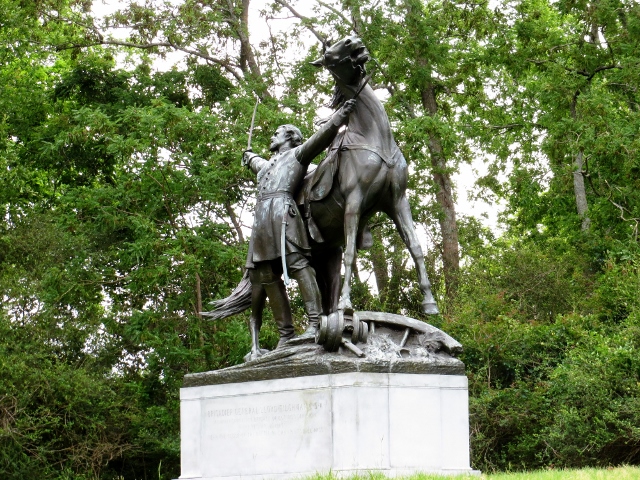
On a beautiful day, I took time to do a ten-mile hike around the Chickamauga Battlefield which looks today very much like it did in 1864. See the many pictures attached. It is a strange feeling to be in such a peaceful setting where so many died.
 |
| Stones River Visitor Center. (Photo by Susan Alton.) |
 |
| Chickamauga Battlefield Visitor Center. (Photo by Susan Alton.) |
Eastern, which focused primarily on Virginia and surrounding states and included the capitals of both belligerents, Washington and Richmond. Except for his one major offensive foray into Pennsylvania at Gettysburg, General Robert E. Lee did the majority of fighting in Virginia and Maryland. We will address those battle sites when we arrive in Richmond at the end of April and in May when we visit Gettysburg.
Trans-Mississippi, which included any action west of the Mississippi. While there were many smaller battles in the West, there were no "major" battles fought west of the river. Union strategy from the beginning of the war was to control the Mississippi River and split the Confederacy, keeping them from resources in the West. This objective was accomplished relatively quickly with a superior navy by controlling major tributaries.
As a side note, a few weeks ago we passed by Picacho Peak between Tucson and Phoenix which was the site for the westernmost skirmish between the armies when a rebel scouting party ran into Union soldiers from California in the Arizona desert.
Middle Tennessee, where overland armies fought tenaciously over territory even when the outcome of the war was decided. These included battles at Shiloh in southwestern Tennessee (one of the bloodiest battles in the war), battles near Nashville (two different times) at Stones River and Franklin, and around Chattanooga. The campaigns set the stage for General William Tecumseh Sherman's March to the Sea after his sacking of Atlanta.
Nashville was the first Confederate capital to fall and soon Memphis and New Orleans were in Union hands. When General Ulysses S. Grant took Vicksburg the same day as the Union victory at Gettysburg, the North has surrounded the Deep South. This move, in conjunction with the blockade of southern ports, completed the "Anaconda" plan of isolating the South from outside resources.
 |
| The bluff overlooking the Mississippi River from downtown Memphis. (Photo by Susan Alton.) |
While in Memphis, Tennessee, at the beginning of April, we saw the bluff on the Mississippi River where many Memphis citizens watched the 90-minute naval battle between nine Union Ironsides and rams and what passed for the Confederate navy. While the South sunk one Union vessel, they were overwhelmed, losing eight "Cottonsides." The city became an important base of operations for Grant as he planned his Vicksburg campaign.
From Memphis, we traveled to Nashville, passing within several miles (on the freeway) of the Shiloh Battlefield. This early battle in southwestern Tennessee pitted Grant against General Albert Sidney Johnson and was typical of many encounters between the armies. The Confederates won the first day of fighting, only to lose their gains as better equipped and reinforced Union troops refused to yield and ended up forcing the rebels to retreat to Mississippi. Of the estimated 100,000 participants, over 23,000 were killed, wounded or missing in the battle, the most ever in any battle to that time (although eight more Civil War battles would surpass those numbers by the war's end).
A trend evolves in this battle which can be seen in most other engagements -- the focus on either water transport (in Shiloh, the Union navy kept the North supplied and provided firepower from ship-mounted cannons) or a reliance on the railroads. Control of the railways was always a primary objective of all conflicts throughout Tennessee.
While in Nashville, we toured the state capitol which was occupied by the Union army for most of the war. Tennessee was an interesting case as the state was split between northern and southern sympathies. It was the last state to secede from the Union and the first to return after the fighting. It sent troops to both the Union and Confederate armies. For a time, there were both Federal and Confederate governors.
After Nashville fell to the north, it became the base for Union forays deeper into Confederate territory. About 28 miles south of Nashville, outside of Murfreesboro, Tennessee, along the Stones River, the armies met for a large battle in April 1863. Both Presidents, Abraham Lincoln and Jefferson Davis, were frustrated with their generals for their inactivity. Both General William Rosecrans for the North and General Braxton Bragg leading the South wanted more time to prepare, plan and train troops for battle, but were forced by political leaders to engage the enemy.
 |
| Stones River National Battlefield. (Photo by Susan Alton.) |
 |
| Enlarge to read this. (Photo by Susan Alton.) |
Considered an important victory for the North, the casualty count was extremely high, 24,000 or over 31% of the soldiers killed, wounded, or missing. For the rest of the war, Nashville was a secure Union base and provided support for future intrusions into the Deep South.
 |
| Hazen Brigade Monument at Stones River. (Photo by Susan Alton.) |
 |
| Stones River - U.S. National Cemetery. (Photo by Susan Alton.) |
Chattanooga was a very important river port and railway hub for the South. It provided protection for Atlanta, 100 miles to the southeast, the major city in the South after Richmond. During the build-up to conflict, the Confederates reinforced their numbers with troops from Virginia that arrived by railroad. The North was being supplied from Nashville.
There were actually three battles for Chattanooga. The first, early in the war (1862) was a light bombardment of Union troops against the entrenched rebels and resulted in the Union army retreating after light casualties.
Then, in 1863, after Stones River and the resulting campaign for middle Tennessee, Confederates retreated to Chattanooga but could not hold the city. Rosecrans deceived southerners guarding the city by releasing construction debris upriver from the city to give the impression of a crossing at that location when, in fact, his army was crossing on pontoon bridges downriver from the city. When the Confederate General Bragg realized what happened, he retreated ten miles south to Lafayette, Georgia, where he established his headquarters with 60,000 troops. Union General Rosecrans assembled his 65,000 men in Chattanooga and marched south to meet Bragg in what would become the second bloodiest battle of the war at Chickamauga Creek.
After several weeks of preparation, the actual battle lasted two days, spread out across a front of four miles. The Confederates earned a rare victory, sending the Union troops back to Chattanooga. The battle was won not by any grand strategy, but through very close fighting, often shrouded in gunsmoke hanging in the trees. Combatants were often on top of each other in the woods before they engaged.
The generals did not know the positions of their own men much less the enemy and had to make decisions without good information. This, coupled with poor communication, left a significant gap in the Union lines which several brigades of southern soldiers exploited. They could not rout the northern troops thanks to General George Henry Thomas (nicknamed "The Rock of Chickamauga") who held back the rebel thrust long enough for the remaining Union armies to retreat back to Chattanooga. The exhausted Confederate soldiers were not in a position to chase them. Over 34,500 men were killed, wounded, or missing in two days of fighting.
After the Union army retreated, Confederates took up positions on the high ground surrounding the city and began a two-month siege. This engagement was the third battle of Chattanooga. After General Grant opened up railroad lines to resupply Chattanooga from the north, the Union army defeated Confederates at Lookout Mountain and Missionary Ridge and began what is known as the Atlanta Campaign in 1864. While these battles were smaller than the larger conflicts, they were dramatic affairs involving significant heroism from Union soldiers advancing against an entrenched enemy holding the higher ground.
The battle for Lookout Mountain (which towers 2,000 feet above Chattanooga) is called the Battle Above the Clouds as fog and low clouds obscured Union troop movements. 18,000 participants fought with very few casualties as northern soldiers surrounded the mountain and forced the southerners to retreat.
 |
| View of Chattanooga from Lookout Mountain. (Photo by Susan Alton.) |
 |
| Confederate position on Lookout Mountain. (Photo by Susan Alton.) |
Southeast of the city at Missionary Ridge, in a coordinated attack, 56,000 Union troops engaged 44,000 southerners in a one-day action. Several troops were commanded to storm rebel rifle pits at the base of the mountains and wait for further orders. No one knows why, but when the northern soldiers accomplished their goal of the rifle pits, they just kept storming up the hill and overwhelmed Confederates on the ridge and claimed victory.
There were many heroic stories that emerged from these battles which were fought by men from all over the country. As one of the first Civil War battlefields to be preserved, with many participants from each side attending multiple reunions, there ended up being 705 memorials, markers, and explanatory signs documenting the action, most erected by state governments commemorating contributions to the battle by their citizens.
 |
| Hiking trail at Chickamauga. (Photo by Robert Alton.) |
 |
| Creek crossing at Chickamauga Battlefield. (Photo by Robert Alton.) |
 |
| Woods to a meadow. (Photo by Robert Alton.) |
 |
| Monuments and signs all over. (Photo by Robert Alton.) |
 |
| More monuments. (Photo by Robert Alton.) |
 |
| Typical explanatory sign. (Photo by Robert Alton.) |
 |
| Monument at Chickamauga Battlefield. (Photo by Susan Alton.) |
 |
| Another monument at Chickamauga Battlefield. (Photo by Susan Alton.) |
 |
| More battlefield scenes. (Photo by Robert Alton.) |
 |
| There were cannons all over the place. (Photo by Robert Alton.) |
 |
| Another monument. (Photo by Robert Alton.)  (Photo by Robert Alton.) |