
We are still camping on the Olympic Peninsula, but today Diane Howell Evans and I are walking on the Kitsap Peninsula in Silverdale, Washington. This walk explores the Old Town Historic District, the waterfront, and portions of the Clear Creek Trail. This walk is familiar to us, but apparently, a few changes have been made in the past year.
The walk starts at Silverdale Waterfront Park. Our route today consists of sidewalks, road shoulders, boardwalks, and trails.
At the beginning of the walk, we took city streets to a trail leading to the beach. On the beach, we walked toward a boat launch but turned away onto a trail before we got to it.
We passed Linder Softball Field at 1 km. Our route then headed uphill to Central Kitsap Middle and High School Complex. Once we entered the middle school grounds, we got on the Johnsonlink Trail. That trail took us all the way around both the middle school and the high school.
 |
| Heading toward Central Kitsap Middle School. |
 |
| We connected to this trail which took us all the way around both schools. |
 |
| Central Kitsap Middle School. |
 |
| Huey Field overlooks Puget Sound. |
 |
| Central Kitsap Middle School. |
 |
| Central Kitsap High School. |
Circling around the schools and ballfields got us to almost 4 km. From here, we exited the school grounds through a trail in the forest. We made our way downhill, turned left at Silverdale Way, and walked on sidewalks to the Clear Creek Trail.
 |
| Diane Howell Evans on a bridge over Clear Creek. |
 |
| A nice mural depicting Silverdale. |
 |
| A boardwalk along the creek. |
Clear Creek brought us out to Puget Sound. Once again, the tide was way out. It seems like our walks each day have been at very low tides!
 |
| Puget Sound. |
We entered Old Mill Park and learned the history of the area. Below is the Wehrhahn Saw.
 |
| Wehrhahn Saw. |

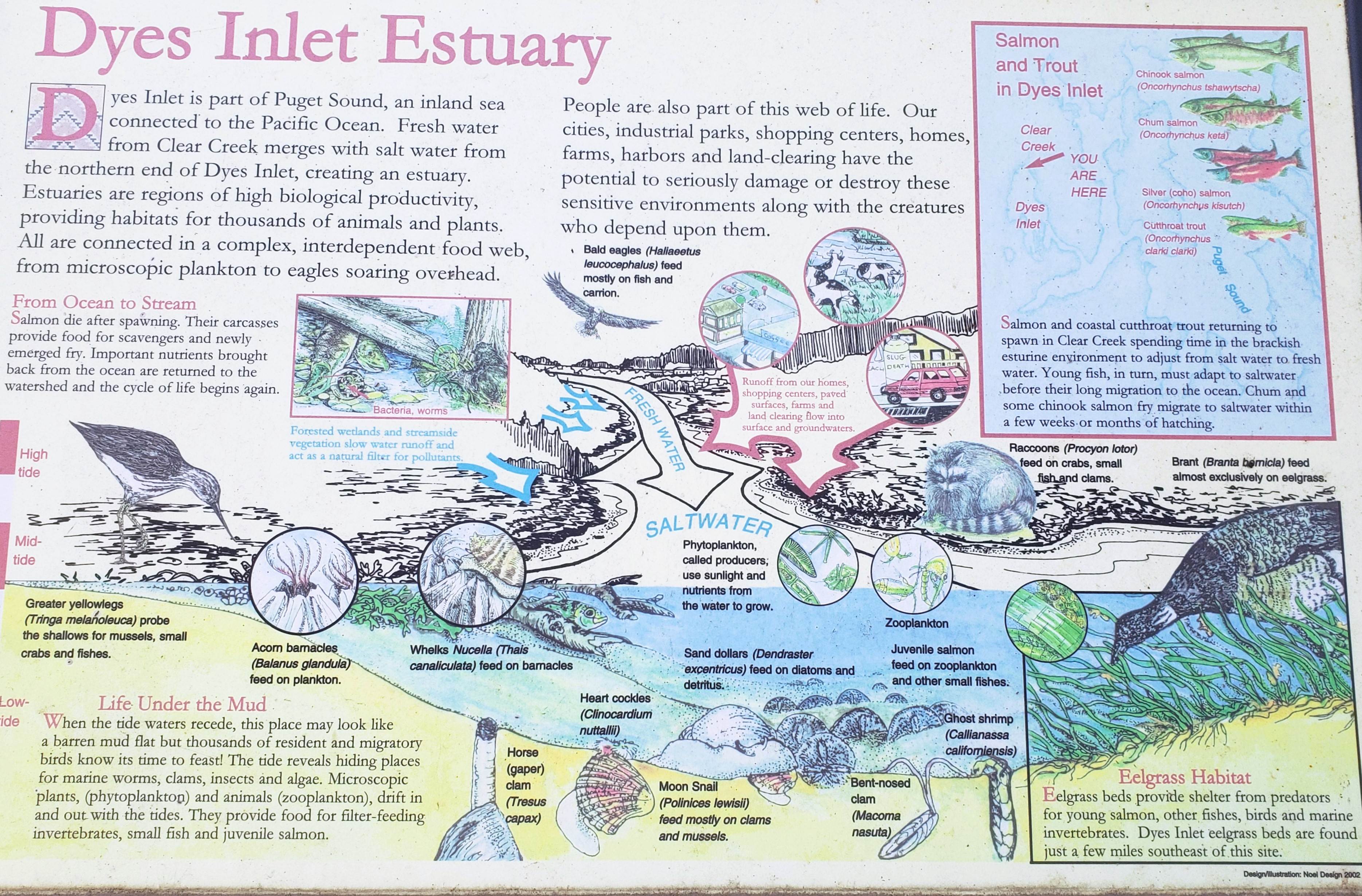 |
| Enlarge this photo to learn all about estuaries. |

We followed the sidewalk around Old Mill Park to the Clear Creek Trail. After walking past the Best Western, turned to walk around the end of Dyes Inlet, onto Bay Shore Drive, past the Yacht Club Broiler Restaurant, and through part of Old Town.
We ended our walk at Silverdale Waterfront Park (where we started). The eclectic art below is on display in the park. I am trying to find out who the artist is and the name of the work.

After the walk, which ended up showing as 11 km on my Garmin, Diane and I had lunch at IHOP. I wonder if all my meandering to take photos added 1 km to our walk?! I then headed back to Evergreen Coho SKP RV Park.
No comments:
Post a Comment
Please let me know what you think, your experiences, and constructive criticism to make this blog stronger.